
Tasha Ancient Road & Panlong Ancient Road Deep-Dive Guide: Cliffside Drives Through the Kunlun, the Legendary Off-Road Route of Xuanzang's Return
Most first-time visitors to Xinjiang fixate on Sayram Lake and the Duku Highway — and then spend summer weekends stuck in Duku traffic jams while the Nalati grasslands drown in selfie sticks. Ask any off-road veteran who has truly crisscrossed Xinjiang which road actually unlocks its most breathtaking soul, and nine times out of ten the answer is the same: the Tasha Ancient Road and the Panlong Ancient Road.
More than a thousand years ago, Master Xuanzang made his pilgrim return through the Kunlun and Pamir ranges, following the very path that threads along the Taxkorgan River deep into the canyon. One side drops sharply into a raging river tens of metres below; the other is a wall of raw, axe-cut rock. Then, further south at Waqia Township, 600+ tightly packed S-bends stretch out across the 4,000-metre plateau — fittingly captioned, "All the winding roads have been walked today. From here on, life is straight ahead."
This guide skips the generic scenic clichés. What you get is hard-earned field experience: exactly how to drive this southern-Xinjiang frontier route safely, dodge the worst pitfalls, and capture the trip's most cinematic shots.
🚙 Veteran Insights: What 600 Bends and Cliff Edges Really Demand From Your Vehicle and Driving
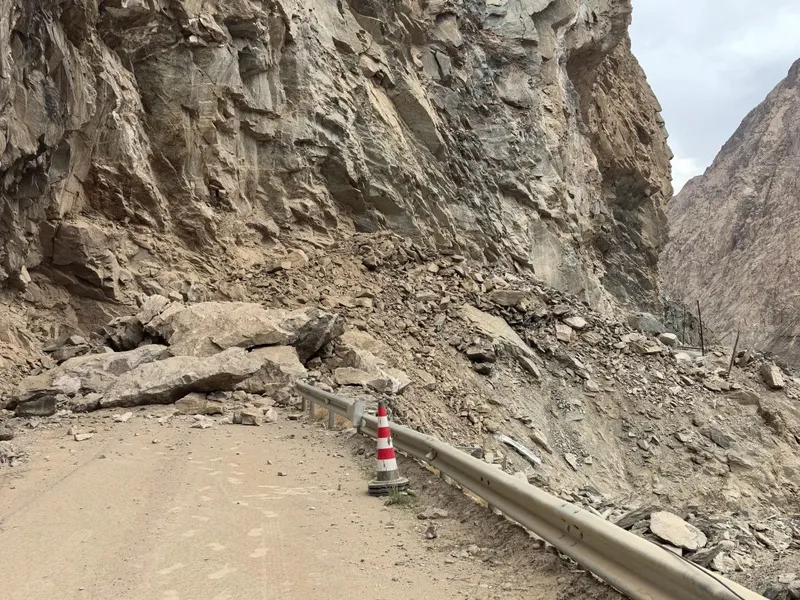
The Tasha Ancient Road (Taxkorgan County to Yarkand County) is not a sightseeing boulevard. Though short stretches have been paved in recent years, nearly 50 km of treacherous washboard road, rockfall zones, and rocky bypasses remain. A single summer flash flood can submerge the bypass. The Panlong Ancient Road climbs from 3,000 m to 4,200 m in altitude, with dozens of kilometres of continuous tight bends brutal on your brakes and suspension.
1. Vehicle Choice
A regular sedan can just barely handle the Panlong Ancient Road, but we strongly discourage taking a sedan through the full Tasha Ancient Road. Loose scree and water crossings along the cliff edge will scrape the underbody and may rupture tyres.
- Recommended: a hardcore 4WD SUV (Toyota Prado, Tank 300, Land Cruiser, or a 4WD off-road van). High ground clearance, confident through water and scree, and strong grip.
- Tyres and brakes: check pressure and brake pads before departure. On long plateau descents, never ride the brakes — learn to downshift and use engine braking.
2. Why Hire a Local Veteran Driver or Guide
Pamir Plateau weather changes by the minute, and rockfalls along the Tasha are unpredictable. An experienced local driver knows the freshest road conditions, the safe bypass tracks, the latest border-pass office updates, and the weather notices — and most importantly, lets you calmly enjoy the vertical cliffs from the comfort of the cabin.
🗺️ 3-Day, 2-Night Southern-Xinjiang Frontier Loop
Avoid backtracking. Depart from Kashgar, link the Karakoram Highway, Pamir Plateau snow peaks, the Panlong Ancient Road, Bandil Blue Lake, and the Tasha Ancient Road, then return to Kashgar via Yarkand (Shache).
Day 1: Kashgar — G314 Karakoram Highway — White Sand Lake — Karakul Lake — Taxkorgan County (≈300 km)
- Pitfall to dodge: before leaving Kashgar in the morning, secure your Border Pass at the Kashgar Administrative Service Center (list "Taxkorgan County"). The Gaizhi checkpoint along the way checks ID and border-pass documents.
- Scenic highlights: White Sand Lake (Baisha Lake) shines like crystal beneath the blue sky and white dunes; at Karakul Lake, you can stand close to the reflection of "Father of Glaciers" Muztagh Ata (7,546 m) mirrored in the alpine water.
- Overnight: Taxkorgan Tajik Autonomous County (≈3,100 m altitude). Move slowly after checking in to prevent mild altitude sickness.
Day 2: Taxkorgan — Waqia Panlong Ancient Road — Bandil Blue Lake — Kukuxiluge Township (≈180 km)
- Panlong Ancient Road photo stop: roughly half an hour out of Taxkorgan you reach the Panlong entrance. Split into "Big Panlong" and "Little Panlong", the full route is about 30 km with 600+ S-bends. Be sure to pose at the iconic black-and-red signboard: "All the winding roads have been walked today. From here on, life is straight ahead."
- Bandil Blue Lake (Kaner Yang Qinglan Lake): just past the Panlong exit, turn into Bandil Blue Lake. The high mineral content gives the water an extreme Tiffany-Blue under direct sunlight, framed by stark black-grey mountains — a striking visual contrast.
- Veteran tip: tonight, stay in a Tajik homestay near the Tasha Ancient Road entrance (Kukuxiluge Township) for the genuine Tajik cultural experience, including a steaming cup of yak milk tea.
Day 3: Kukuxiluge Township — Tasha Ancient Road Cliff Section — Artush Water Control Hub — Yarkand — Kashgar (≈280 km)
- Tasha Ancient Road cliff crossing: this is the most thrilling stretch of the trip. The vehicle hugs sheer cliffs dozens of metres high, with the roaring Taxkorgan River directly below. The valleys on both sides look knife-cut, narrowing to single-vehicle width.
- Yarkand culture and food: emerging from the gorge into Yarkand, the vibe changes completely. Yarkand is the birthplace of the UNESCO intangible heritage "Twelve Muqam". Spend the afternoon at the Yarkand Intangible Cultural Heritage Park (Amannisahan Memorial Mausoleum) for the rich Silk Road culture, then head into the old town for a proper bowl of Yarkand pigeon soup, baked buns, and a fresh-baked naan.
- Return to Kashgar: take the Tuhe Expressway or G315 back to Kashgar and close this frontier adventure.
🎒 Packing Checklist: Essentials for the Frontier Off-Road
⚠️ Don't say we didn't warn you: the middle section of the Tasha Ancient Road has almost zero mobile signal and no restaurants or convenience stores.
- Documents: original ID + Border Pass (both mandatory; border checks are extremely strict).
- Clothing: huge temperature swings on the plateau — even in July–August, pack a windproof shell plus a warm mid-layer.
- Altitude protection: Rhodiola (start one week prior), glucose oral solution, altitude-sickness headache meds, and a small oxygen canister.
- Motion sickness: with 600+ bends on the Panlong, take your motion-sickness pills 30 minutes before entering the road.
- Emergency supplies: 2–3 days of drinking water, high-calorie snacks (energy bars, beef jerky), a torch, and a high-capacity power bank.
💡 Real Talk: A Few Hard Truths
Don't force the Tasha Ancient Road in heavy or prolonged rain: the cliff walls are mostly weathered scree; heavy rain almost always triggers local rockfall and landslides. On rainy days, turn back via the G314 to Kashgar.
Follow the one-way rule on the Panlong Ancient Road: never drive the wrong way to save time, and never stop in tight bends to take photos. Blind corners are huge, and random stopping is genuinely dangerous.
Yarkand Old Town is more authentic than Kashgar Old Town: if your schedule allows, spend an extra half-day in Yarkand. The teahouses and alleys are far less commercial, and the original local life is wonderfully intact.
📸 Don't Snap Randomly — These Few Vantage Points Are Killer
- Panlong "Little Panlong" panoramic lookout: stand at the summit overlooking the 600+ densely packed bends as a great dragon coiling across the black-brown mountain — a wide-angle lens or drone delivers the most dramatic shot.
- Panlong Ancient Road entrance sign: at the famous black-and-red sign reading "All the winding roads have been walked today. From here on, life is straight ahead", pose sideways for a ritual-worthy shot.
- Bandil Blue Lake bridge cliffside: stand at the bridge head or the side slope, framing the modern bridge, the Tiffany-blue lake, and the stark arid mountains behind it.
- Tasha road washout cliff section: compose through the rear-view mirror or side window to capture the off-road tension of the vehicle hugging the cliff with the deep gorge river below.
💬 What Our RoamFun Travellers Say
"Finishing the Tasha and Panlong Ancient Roads is the only way to truly understand what a frontier highway is. When I read that caption 'From here on, life is straight ahead' at the Panlong entrance, my eyes genuinely welled up. Huge thanks to RoamFun's local driver — he knew every road-condition pitfall and handled the vehicle flawlessly the entire trip." — Mr. Mo, Guangzhou ⭐⭐⭐⭐⭐
"I thought the Duku Highway was already mind-blowing, but the Tasha Ancient Road completely rewrote my understanding of Xinjiang. Sheer cliffs with raging rivers below, and once we descended to Yarkand we tasted the best roast pigeon and naan of our entire Xinjiang trip. Absolutely an experience I'll never forget." — Lirian, Shanghai ⭐⭐⭐⭐⭐
The Wind of the Kunlun and the Vertical Walls Await You
Over a thousand years ago, Master Xuanzang rode a lean horse through these cliffs; today, the Kunlun still whispers of time and faith. This is not a casual walker's route — it's a frontier pilgrimage for the brave and the deeply curious.
Want a Worry-Free, Safe Frontier Off-Road Experience?
Don't want to wrestle with complex planning or the stress of risky mountain driving? Reach out to a RoamFun Senior Travel Consultant now for a tailor-made southern-Xinjiang roadbook and quote — yours alone.
Get Your Free Roadbook & Quote
Updated: August 2026 Author: RoamFun Senior Travel Consultant Questions? Reach us at: vip@roamfun.net
Craving a worry-free yet free-spirited journey?
Don't want to plan it yourself? Contact our senior trip designer now for a route and quote tailored to you.

RoamFun Senior Travel Consultant
Travel DesignerProfessional travel consultant, curating the most practical travel guides for you.