Southern Xinjiang Taklamakan Desert Crossing Guide: Into the Heart of China's Largest Desert
Taklamakan—in Uyghur, it means "go in and you won't come out." China's largest desert, covering 330,000 square kilometers—roughly the size of Germany. The desert highway cuts 560km straight through from Luntai to Minfeng, flanked by endless golden dunes and reed-grid sand barriers forming a "Great Green Wall."
This isn't an ordinary road trip—it's a crossing. Before departing, you must know: where are the supply stations, what to do if you run out of fuel, where to shelter when a sandstorm hits.
A Veteran's Honest Truth: Not Just Any Vehicle Can Enter the Desert
Sedans can't enter the desert—no explanation needed. Urban SUVs have an 80% chance of getting stuck in sand. The desert highway itself is paved, but once you leave the highway to go deep into the desert heartland (like to Darya Boyi), a hardcore off-roader is mandatory.
Prado + low tire pressure for sand (adjusted to 1.2-1.5 bar for sand buoyancy), 4WD lock, tow rope + sand boards + shovel—these aren't optional accessories. A veteran driver who's run the desert dozens of times knows the visual characteristics of soft sand (white-colored sand is soft—go around it), knows how to escape when stuck (don't floor the gas—the more you dig, the deeper you sink).
3-Day Desert Crossing Route
Day 1: Kuqa — Luntai — Desert Highway Start — Tazhong (approx. 350km)
- Route tip: The Luntai-to-Tazhong section has gas stations roughly every 200km, but from Tazhong to Minfeng there's only 1 station. Fill up at half a tank.
- Veteran advice: Afternoon desert—dunes glow golden in side-backlight. Find any safe parking area, walk up, stand on the sand ridge line—Taklamakan on the left, Taklamakan on the right. 360 degrees of golden sand sea.
Day 2: Tazhong — Darya Boyi (if open) or deeper into the desert heartland
Darya Boyi is an ancient village in the Taklamakan's heart. The Keriya River flows out from deep within the desert, nourishing a poplar forest and several hundred Keriya people. Reaching the village requires about 130km of desert road (unpaved), demanding extremely high vehicle capability and driving skill.
Day 3: Desert Highway — Minfeng
The desert highway reaches its end—Minfeng County town. Return from golden sand sea to civilization. Eat a proper Southern Xinjiang bowl of banmian noodles and grilled lamb in Minfeng—every bite is the accumulated sense of achievement from three days.
Essential Checklist
⚠️ Don't say I didn't warn you: Cell signal is extremely poor in the desert (most sections have no signal), and day-night temperature swings are extreme (30°C daytime, possibly 10°C at night). When a sandstorm hits, visibility drops to 5 meters—immediately pull over, close windows, and wait it out.
- At least 3L drinking water per person + high-calorie dry rations
- Sun-protection face mask + sunglasses + long sleeves (sand gets everywhere)
- Tow rope + sand boards + shovel + air pump (for self-deflation/inflation)
- Satellite phone or inform family/friends of your itinerary in advance
Heart-to-Heart Honest Truths
Don't cross the desert during the hottest afternoon hours: 2-4 PM surface temperatures can reach 60-70°C. Tires and engines are working at their limits. Depart at 6 AM, rest at Tazhong at noon, continue after 4 PM.
Don't panic when a sandstorm comes: Close windows, pull over, wait. Sandstorms typically last 15-30 minutes. Don't drive in a sandstorm—visibility is zero.
Never enter the desert alone: Travel with at least two vehicles. If one gets stuck, the other can tow it out.
Don't Shoot Blindly—These Spots Are Incredible
- Desert highway depth: Stand in the middle of the road and shoot forward—straight highway extending to the horizon, endless desert on both sides.
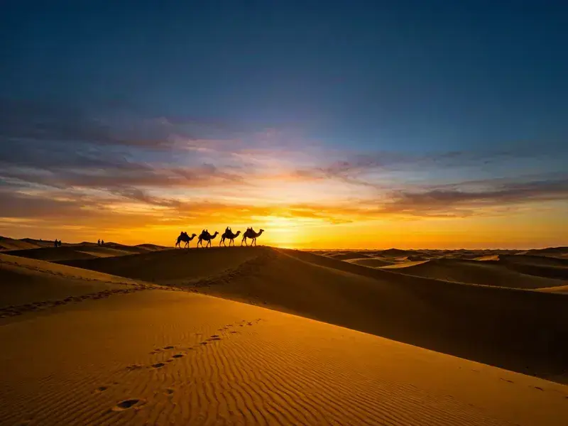
- Camel silhouettes on sand ridges: Shoot at sunrise or sunset—golden dunes + camel silhouettes + distant horizon.
- Poplar groves at night: Poplar and tamarisk along the desert highway—sunset through the branches of dead poplar trees.
What RoamFun Travelers Say
"Stood on a dune beside the desert highway. 360 degrees of golden sand. So quiet I could hear my own heartbeat. That moment you finally understand—why Taklamakan means 'go in and you won't come out.' Not because it's dangerous, but because you don't want to leave." — A'zhe, Chengdu ⭐⭐⭐⭐⭐
In Taklamakan, You Truly Feel "Vast"
330,000 square kilometers—you drive through it for three days and still only see one corner. Taklamakan gives you no illusion of conquering it—it's too big, so big that inside it, you're just a grain of sand.
Craving a worry-free yet free-spirited journey?
Don't want to plan? Contact our senior custom designers now for your exclusive route and quote.
Updated: June 2026 Author: RoamFun Senior Travel Consultant For questions, contact: vip@roamfun.net

RoamFun Senior Travel Consultant
Travel DesignerProfessional travel consultant, curating the most practical travel guides for you.