Xinjiang–Tibet Highway G219 Self-Drive Guide (Entering Tibet from Yecheng)
The Xinjiang–Tibet Highway (G219 Yecheng section) is one of the highest-altitude roads in the world, crossing the Kunlun and Karakoram ranges from Yecheng in Xinjiang into Tibet, nicknamed the "Sky Road." Its snow mountains, passes, deserts, and extreme altitude create a stark, wild beauty — the ultimate dream of countless self-driving enthusiasts. Stretching from the edge of the Taklamakan Desert in Xinjiang to Tibet's Ali region on the roof of the world, this road lets you see desert, snow mountains, Gobi, and highland lakes in a single journey, grand and boundless.
But it is also the most "demanding" route into Tibet. There is no lush greenery like the Sichuan–Tibet line or the gentle charm of the Yunnan–Tibet line; instead there is the cold test of average altitudes above 4,000 meters and hundreds of kilometers of uninhabited wasteland. Some say you only truly understand what a "road" means after traveling the Xinjiang–Tibet line. That is why it is called self-drivers' "graduation route" — those who complete it, in both body and mind, count as genuinely seasoned drivers.
But a fair warning: this road's high altitude, long no-man's-land stretches, and scarce supplies mean it suits only prepared, experienced self-drivers. This guide covers the route overview, road characteristics, essential preparations, supply points, and high-altitude driving essentials — all in one place, so you are fully ready before setting off.
🗺️ Route Overview
- Start: Yecheng, Xinjiang (km 0)
- Via: Kudi Pass, Mazar Pass, Heika Pass, Kangxiwa, Dahongliutan, Sanshiliyingfang, Jieshan Pass
- End (this section): Enters Tibet, then to Ritu / Shiquanhe, connecting to Ali
- Full line: G219 runs through Xinjiang–Tibet; this guide focuses on the Yecheng–Tibet section
Key passes (extremely high):
- Kudi Pass: about 3,200 m
- Mazar Pass: about 4,900 m
- Heika Pass: about 4,900 m
- Jieshan Pass: about 5,300 m or higher (one of the highest points)
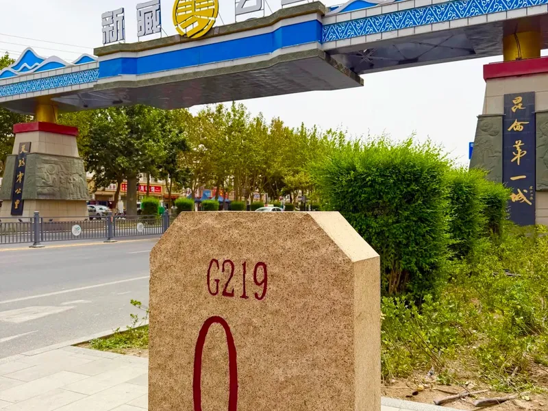
From the km-0 marker at Yecheng, the Xinjiang–Tibet line climbs the Kudi, Mazar, and Heika passes, passes Kangxiwa, Dahongliutan, and Sanshiliyingfang, then crosses Jieshan Pass above 5,300 m into Tibet's Ali region. Mazar and Heika passes both approach 4,900 m, and Jieshan is among the highest points. Most of the road runs above 4,000 m — a double test of body and vehicle.
⚠️ Features and Risks of This Road
- Extremely high altitude: Long stretches at 4,000–5,300 m mean high risk of altitude sickness
- Long no-man's-land: Between Yecheng and Dahongliutan, hundreds of kilometers with no town supply
- Scarce supplies: Gas, dining, and lodging points are few — plan ahead
- Complex road conditions: Some passes are winding dirt or gravel roads, prone to landslides in the rainy season
The Xinjiang–Tibet line's defining features are "high, remote, and desolate." Altitude is extreme, with long stretches between 4,000 and 5,300 m and high altitude-sickness risk; the no-man's-land is very long, with several hundred kilometers between Yecheng and Dahongliutan without towns; gas stations, restaurants, and lodgings are all extremely scarce, requiring advance planning; and road conditions are complex, with some passes being winding dirt or gravel roads and rainy-season landslides. These risks combined mean the road suits only experienced self-drivers fully prepared physically and mentally.
📋 Essential Preparation
Documents:
- ID card, driver's license, vehicle registration
- Border pass: Required for entering Tibet and border areas — arrange it in advance in your registered hometown or Yecheng
Vehicle:
- Four-wheel-drive off-roader / SUV, in good condition with high clearance
- Spare tire, tow rope, spade, snow chains, spare fuel can
- Full inspection before departure; fill the tank (gas stations are scarce en route)
Supplies:
- Portable oxygen, red ginseng and other altitude-sickness remedies
- Plenty of water, dry food, warm clothing, and a sleeping bag
- Satellite phone / power banks, and cash (signal is poor on some sections)
Preparation largely decides the trip's success. For documents, bring your ID, driver's license, and vehicle registration, and make sure to obtain the border pass for entering Tibet and border areas in advance, either in your registered hometown or in Yecheng. For the vehicle, drive a four-wheel-drive off-roader or SUV in good condition with high clearance; carry a spare tire, tow rope, spade, snow chains, and a spare fuel can; inspect thoroughly and fill the tank before departure. For supplies, portable oxygen and altitude-sickness remedies are essential, along with plenty of water, dry food, warm clothing, and a sleeping bag; bring a satellite phone or power banks, and keep cash since signal is poor on some sections.
🛣️ Route and Supply Points
- Yecheng → Kudi: about 110 km, with lodging and supplies
- Kudi → Sanshiliyingfang: crossing Mazar and Heika passes; long and slow — Sanshiliyingfang is a key supply point
- Sanshiliyingfang → Dahongliutan: fewer supplies
- Dahongliutan → Jieshan Pass → enter Tibet: cross Jieshan Pass into Ali
Plan the whole route over 3–4 days, crossing only 1–2 passes per day to avoid fatigue and severe altitude sickness.
Planning supplies is the most critical part of the whole trip. From Yecheng to Kudi is about 110 km with lodging and supplies; from Kudi to Sanshiliyingfang you cross the high-altitude Mazar and Heika passes — long and slow, making Sanshiliyingfang the most important supply point on this stretch; between Sanshiliyingfang and Dahongliutan supplies are scarce, so prepare in advance; finally, cross Jieshan Pass from Dahongliutan into Tibet. Plan the whole route over 3–4 days, crossing only 1–2 passes daily to avoid fatigue and severe altitude sickness.
💡 High-Altitude Driving and Handling Altitude Sickness
- Drive slowly, avoid strenuous movements, and prevent altitude sickness
- When crossing passes, use a low gear and control speed; use engine braking downhill
- Check real-time road conditions before departure and avoid bad weather
- If altitude symptoms are obvious, descend or use oxygen promptly — do not push through
- In no-man's-land, travel in a group — do not head into remote areas alone
High-altitude driving and handling altitude sickness are the most critical skills on this road. Drive slowly throughout, avoiding strenuous movements that trigger altitude sickness; when crossing passes, use a low gear and controlled speed, and use engine braking downhill to save your brakes and stay safer; check real-time road conditions before departure and avoid bad weather. If altitude symptoms become obvious, descend or use oxygen promptly — never push through. In no-man's-land, travel in a group rather than heading in alone. Safety always comes first.
📌 Practical Tips
- Gas stations are scarce — fill up at every station you see
- Some sections have no signal — download offline maps in advance
- In border areas, be careful with photography — do not casually shoot sensitive zones
- Respect the plateau ecosystem — take your trash with you
A few practical reminders: along the route gas stations are extremely scarce, so "fill up at every station you see"; some sections have no signal, so download offline maps in advance; in border areas be careful with photography and do not casually shoot sensitive zones; and please respect the plateau ecosystem — take your trash with you and leave no pollution on this pristine land.
The Xinjiang–Tibet Highway is self-drivers' "graduation route" — beautiful in its extreme wilderness, difficult in its extreme altitude. Prepare thoroughly and match your limits, and you can truly enjoy this Sky Road's grandeur. It is not just a road but a long conversation about endurance, courage, and the beauty of nature.
If you long for the Xinjiang–Tibet line but worry about the high altitude, no-man's-land, and supplies, consider planning with an experienced highland self-driving team. They have mature routes and contingency plans to bring you this ultimate wilderness beauty safely. Match your limits, prepare well, and the Sky Road will open for you.
Craving a stress-free yet free-spirited trip?
Don't want to plan? Contact our senior trip designer now for a personalized route and quote.
Get Your Free Itinerary & Quote
Updated: August 2026 Author: RoamFun Senior Travel Advisor Questions? Contact us: vip@roamfun.net

RoamFun Senior Travel Consultant
Travel DesignerProfessional travel consultant, curating the most practical travel guides for you.