Duku Highway: North or South Section? Full Comparison of Scenery, Road Conditions & Time
The Duku Highway (G217, Dushanzi–Kuqa) runs about 561 km across the Tianshan Mountains, known as "one of China's most beautiful roads." It condenses Xinjiang's most iconic landscapes — snow mountains, grasslands, canyons, wetlands, and yadan landforms — into a single route where seasons change within a day, a "must-drive in this lifetime" for countless self-drivers. But many do not realize that its north and south sections differ completely in scenery and difficulty — choosing wrong could mean missing the very landscape you came to see.
The Duku Highway is legendary precisely because it crosses the Tianshan and links northern and southern Xinjiang. Thanks to this road, two regions once requiring a detour of over a thousand kilometers became a short drive apart. Along the way you climb several high-altitude passes, passing from lush grassland to barren red-layer canyon as if walking through four seasons in a single day. That is why spending your time wisely matters so much.
This article breaks the north and south sections down across four dimensions — scenery type, altitude difference, road difficulty, and driving time — and offers a two-day full north–south loop plan, so you can choose correctly and explore thoroughly based on your trip length and scenic tastes.
🗺️ First, Understand the Sections
Duku Highway is naturally divided at Nalati / Bayinbuluke into north and south sections:
| Section | Route | Length | Highest Point |
|---|---|---|---|
| North | Dushanzi → Nalati / Qiaoerma | about 250 km | Hashilegen Pass (about 3,400 m) |
| South | Bayinbuluke / Nalati → Kuqa | about 310 km | Tielimaiti Pass (about 3,200 m) |
The north leans toward cold high snow mountains; the south leans toward canyon red layers. The two have completely different characters.
Understanding the division is the first step in choosing. The Duku Highway naturally splits into north and south sections at the Tianshan. The north starts from Dushanzi, climbing the roughly 3,400-meter Hashilegen Pass, passing alpine grassland and glacier snow mountains; the south continues from Bayinbuluke or Nalati, crossing Tielimaiti Pass into reddish canyon country. The two styles are worlds apart, and your choice is essentially between "wanting snow mountains" and "wanting canyons."
⛰️ Scenery Differences (Core Highlights)
North (Dushanzi–Nalati):
- Snow mountains & glaciers: Crossing Hashilegen and Yuximolegai passes, the road winds between snow mountains; even in July you can see snow and glaciers
- Canyons & grassland: Dushanzi Grand Canyon, Qiaoerma Martyrs' Cemetery, and Nalati Grassland all lie along the north
- Colors: Dominated by green grassland + white snow + gray-black rock, grand and powerful
South (Bayinbuluke–Kuqa):
- Alpine wetlands: Bayinbuluke Swan Lake and Nine Bends and Eighteen Curves
- Red-layer canyon: Tianshan Mysterious Grand Canyon (Kuqa Canyon), with ochre-red cliffs contrasting sharply with the blue sky
- Yadan landforms: Unusual formations near the Kuqa end
- Colors: Dominated by red-brown cliffs + green grassland + blue sky, with strong light contrast
In one sentence: Choose the north for snow mountains and glaciers; choose the south for red canyons and wetlands.
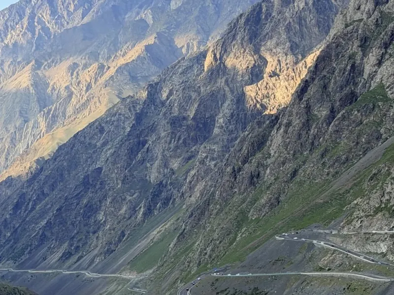
Scenery is the Duku Highway's biggest selling point and its most obvious difference. The north's soul is snow mountains and glaciers — in July, climbing the passes you still see snow piled beside the road, set against rolling grassland and a deep canyon, grand and awe-inspiring. The south's soul is red canyons and wetlands — ochre-red cliffs that stand out sharply under the blue sky, while Bayinbuluke's Nine Bends shows the softness of grassland wetlands. In short: want snow mountains, take the north; want red canyons and wetlands, take the south.
⚠️ Road Conditions & Driving Difficulty
| Aspect | North | South |
|---|---|---|
| Curves / slopes | Steeper, sharper curves, more mountain sections | Relatively gentler, but with some continuous curves |
| Altitude | Up to about 3,400 m, slightly higher altitude-sickness risk | Up to about 3,200 m |
| Rockfall / gravel | Many cliff-edge sections; watch for rockfall | Some rockfall risk in canyon sections |
| Recommended vehicle | Four-wheel-drive / high-power SUV or off-roader | Ordinary SUV is sufficient |
| Beginner friendliness | Lower | Higher |
Driving advice:
- The speed limit is 40–60 km/h throughout — do not exceed it
- Avoid fatigue driving on high-altitude mountain roads; rest every 2 hours
- July–August is the open season, but temporary closures may occur due to weather; check real-time road conditions before departure
In terms of driving difficulty, the north is clearly more challenging than the south. The north has more mountain switchbacks, sharper curves, and steeper slopes, with a slightly higher maximum altitude — less beginner-friendly, so a high-power four-wheel-drive SUV or off-roader is recommended. The south is relatively gentler, and an ordinary SUV suffices. Whichever you take, respect the 40–60 km/h speed limit, avoid fatigue on mountain roads, and stop to rest every two hours. July–August is the open season, but weather can cause temporary closures, so always check real-time conditions before you set off.
⏱️ Time Comparison
- North full route: about 4–5 hours of pure driving (excluding photo stops)
- South full route: about 5–6 hours of pure driving
- Full north–south loop: Dushanzi→Kuqa, plan 2 days, staying overnight at Nalati or Bayinbuluke
Short on time? With only 1 day and wanting the highlights, choose the north (snow mountains + canyon + grassland in one go); with 2 days, drive both sections to leave no regrets.
For time, the north takes about 4–5 hours of pure driving and the south about 5–6 hours — but neither includes photo stops, and every viewpoint on the Duku Highway makes it hard to keep moving. If you have only 1 day, choose the north, where the highlights of snow mountains, canyons, and grassland can all be collected in one go. If you have 2 days, definitely drive both sections so you do not miss the two utterly different landscapes this road offers.
🚗 Two-Day North–South Loop Plan
Day 1 (North): Dushanzi → Dushanzi Grand Canyon → Qiaoerma → Hashilegen Pass → Nalati Grassland, overnight in Nalati Day 2 (South): Nalati → Bayinbuluke Nine Bends → Tielimaiti Pass → Tianshan Mysterious Grand Canyon → Kuqa
Note: Duku Highway typically opens mid-June to October, subject to that year's announcement; it is fully closed in winter.
With ample time, strongly consider the full two-day loop: on day one drive the north, starting from Dushanzi, visiting Dushanzi Grand Canyon, crossing Hashilegen Pass, and staying overnight at Nalati Grassland; on day two head south, see Bayinbuluke's Nine Bends, cross Tielimaiti Pass, reach Kuqa, and stop at Tianshan Mysterious Grand Canyon along the way. This covers both sections and lets you see snow mountains, grassland, wetlands, and canyons in one trip — the most complete experience. Remember the Duku Highway usually opens from mid-June to October and is closed in winter; confirm the year's announcement before going.
📌 Practical Tips
- Fuel: Nalati, Bayinbuluke, and Kuqa have gas stations, but the middle of the north section has few — fill up before departure
- Supplies: No dining on mountain stretches — pack water and snacks in advance
- Photos: The north's snow-mountain stop is at Hashilegen Pass viewpoint; the south's canyon stop is at the entrance to Tianshan Mysterious Grand Canyon — both are must-stops
- Weather: Mountain weather changes within a day — bring a warm jacket and raincoat
Finally, some practical reminders. Fuel: Nalati, Bayinbuluke, and Kuqa all have gas stations, but the middle of the north section has few, so fill up before you leave. Supplies: there is no dining on the mountain passes, so pack water and snacks. Photos: in the north, the must-stop for snow mountains is the Hashilegen Pass viewpoint; in the south, the must-stop for canyons is the entrance to Tianshan Mysterious Grand Canyon. Weather: mountain weather shifts within a day, so bring a warm jacket and raincoat. With these details handled, your Duku trip will go smoothly.
Once you have read this comparison and matched it to your trip length, you will know which section to take. Whichever you choose, the Duku Highway is a landscape road worth every kilometer. The north's snow mountains and the south's red canyons each have their own thrill — the key is choosing the section that suits you.
If planning the Duku Highway's road conditions, lodging, and fuel stops feels overwhelming, you can also ask an experienced local team to arrange it. They will schedule the north and south sections just right according to your time and preferences, so you can spend your energy on the scenery rather than the logistics.
Craving a stress-free yet free-spirited trip?
Don't want to plan? Contact our senior trip designer now for a personalized route and quote.
Get Your Free Itinerary & Quote
Updated: August 2026 Author: RoamFun Senior Travel Advisor Questions? Contact us: vip@roamfun.net

RoamFun Senior Travel Consultant
Travel DesignerProfessional travel consultant, curating the most practical travel guides for you.